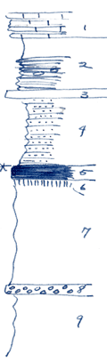
KGS Home

Geology Index Page

Wilson County

Sec. 29, T. 29 S., R. 17 E
Move to another county

Creek banks
Measured By Newell, 8/1938
Compare other nearby sections - Perhaps conglomerate #8 marks an unconformity correlative with that at base of Tonganoxie sandstone
Unit No. Description Thickness
1 Limestone wavy, white, poorly shown, about + 3 ft.
2 Shale, upper 2.3 ft. gray, lower part black, fissile, with phosphatic concretions 6 ft.
3 Dense, blue, fossiliferous limestone 1 ft.
4 Sandstone, slabby, more shaly below 8 ft.
5 Coal with silic wood, mined in nearby strip pit 1.4 ft.
6 Underclay 0.8 ft.
7 Shale, light gray, soft clay shale, unlike that below 11 ft.
8 Conglomerate, limestone pebbles, no fossils 0.4 ft.
9 Shale, flaky, argillaceous  

Original Document

The Archive file you download contains a TIFF image compressed into a ZIP archive. Your browser may be already set up to decompress these files. Commercial software to perform this is available from PKWARE, Inc., the company that invented the format. A web page from a group of people creating shareware or public domain software is available at Info-ZIP. The TIFFs are 150-dpi archival-quality color scans of the original forms and can be viewed by software like Corel PhotoPaint or Adobe PhotoShop.


Kansas Geological Survey
Comments to webadmin@kgs.ku.edu
URL=http://www.kgs.ku.edu/General/Geology/Measured/index.html
Programs Updated May 2003