|
| Unit No. |
Description |
Thickness |
|
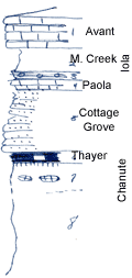
1
|
Limestone, brown, sandy, oolitic, with shale parting, not very fossiliferous
|
+/- 4 ft.
|
|
2
|
Shale, gray, silty
|
3 ft.
|
|
3
|
Shale, black, fissile, w. phosphatic concretions
|
0.8 ft.
|
|
4
|
Fine, hard, yellowish, fossiliferous limestone, shaly below
|
0.5 ft.
|
|
5
|
Sandstone platy, buff
|
8 ft.
|
|
6
|
Coal, with abundant silicified wood (This coal is mined locally, whereas within a half mile another coal, absent here, is mined
|
0.8 ft.
|
|
7
|
Shale, mainly covreed; underclay at top, contains yellow limestone septarians
|
+/- 4 ft.
|
|
8
|
Shale, silty, no sandstone
|
+/- 15 ft.
|
|

