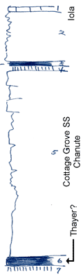
KGS Home

Geology Index Page

Wilson County

Sec. 29, T. 29 S., R. 17 E
Move to another county

Creek bank and roadcut
Measured By Newell, 8/1938
Unit No. Description Thickness
1 Limestone, white, remnant  
2 Sandstone, platy, wave-ripped 8 ft.
3 Coal, abundant silicified wood at top (not mined here, but nearby) 0.8 ft.
4 Underclay 0.4 ft.
5 Sandstone, heavy bedded above, grades downward into sandy shale +/- 31 ft.
6 Coal, mined here +/- 1.5 ft.
7 Underclay  

Original Document

The Archive file you download contains a TIFF image compressed into a ZIP archive. Your browser may be already set up to decompress these files. Commercial software to perform this is available from PKWARE, Inc., the company that invented the format. A web page from a group of people creating shareware or public domain software is available at Info-ZIP. The TIFFs are 150-dpi archival-quality color scans of the original forms and can be viewed by software like Corel PhotoPaint or Adobe PhotoShop.


Kansas Geological Survey
Comments to webadmin@kgs.ku.edu
URL=http://www.kgs.ku.edu/General/Geology/Measured/index.html
Programs Updated May 2003