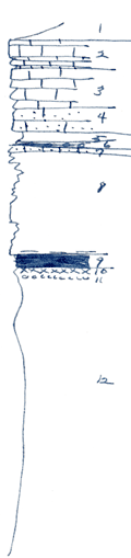
KGS Home

Geology Index Page

Wilson County

Sec. 32, T. 29 S., R. 17 E
Move to another county

Roadcuts
Measured By Newell, 8/1935
Fine exposure of Iola
Unit No. Description Thickness
1 Gray shale  
2 Bluish, granular crinoidal limestone with worm borings shaly breaks (Super) 3 ft.
3 Buff, fine limestone (Upper) with brachiopods (Marginifera, Hustedia, etc.) 4 ft.
4 Very sandy buff limestone 2 ft.
5 Dark gray carbonaceous shale 1.5 ft.
6 Black, fissile shale with phosph concretions 0.2 ft.
7 Sandy crinoidal limestone, brown 0.3 ft.
8 Papery, platy sandstone with silic wood at base 10 ft.
9 Coal 1 ft.
10 Underclay 0.5 ft.
11 marly yellow zone at base of underclay 0.2 ft.
12 Silty gray shale 27 ft.

Original Document

The Archive file you download contains a TIFF image compressed into a ZIP archive. Your browser may be already set up to decompress these files. Commercial software to perform this is available from PKWARE, Inc., the company that invented the format. A web page from a group of people creating shareware or public domain software is available at Info-ZIP. The TIFFs are 150-dpi archival-quality color scans of the original forms and can be viewed by software like Corel PhotoPaint or Adobe PhotoShop.


Kansas Geological Survey
Comments to webadmin@kgs.ku.edu
URL=http://www.kgs.ku.edu/General/Geology/Measured/index.html
Programs Updated May 2003