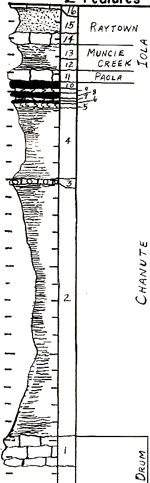
| Unit No. |
Description |
Thickness |
|
16
|
Limestone - light gray (N7) when fresh. Weathers to pale yellowish orange (10YR8/6). Very fossiliferous. Mainly small brachiopods
|
1 in.
|
|
15
|
Sandstone - very fine, angular grains, micaceous, strongly iron-stained, dark yellowish orange (10YR6/6) to light brown (5YR5/6)
|
2.9 ft.
|
|
14
|
Limestone - very sandy and micaceous. Very pale yellowish brown (10YR7/2). Unfossiliferous
|
1.4 ft.
|
|
13
|
Shale - very silty, micaceous, poorly bedded, strongly jointed. Has thin clay layers in upper 8 inches. Becomes very calcareous in upper 3 inches. Yellowish gray (5Y7/2) to pale yellowish orange (10YR8/6)
|
1.7 ft.
|
|
12
|
Shale - fissile, dark gray (N3), breaks into large (3 in.) thin (1/16 in.) plates. Contains zone (1 in. thick) of phosphatic (brown) nodules 11 inches above base
|
1.5 ft.
|
|
11
|
Limestone - clayey and silty, dirty, very fossiliferous, many fusulinids, light gray (N7). Locally iron-stained. Upper 6 in. is limestone rubble
|
1.4 ft.
|
|
10
|
Coal
|
6.5 in.
|
|
9
|
Claystone, medium dark gray (N4), carbonaceous, non-silty
|
5 in.
|
|
8
|
Coal
|
5 in.
|
|
7
|
Claystone, medium dark gray (N4), carbonaceous, non-silty
|
3.5 in.
|
|
6
|
Coal - iron-stained
|
1 in.
|
|
5
|
Claystone, non-silty, purplish gray color near grayish purple (5P4/2) in upper 1/2 inch. Lower 2.5 inches iron-stained badly
|
0.25 in.
|
|
4
|
Shale - medium light gray (N6) to dark yellowish gray (5Y7/1), fissile, non-silty.
|
8.1 ft.
|
|
3
|
Bed of septarian concretions or cross-bedded crystalline limestone. Medium dark gray (N4), very fine crystalline (dense).
|
|
|
2
|
Shale - medium light gray (N6) to dark yellowish gray (5Y7/1), fissile, non-silty
|
28.5 ft.
|
|
1
|
Limestone - brownish gray (5YR4/1) to medium gray (N5). Medium crystalline with many white specks throughout. Fossiliferous, fossils mainly Osagia? algae and small brachiopods. A few crinoid stems. Base not exposed. Joints N25E prominent
|
+ 3 ft.
|