|
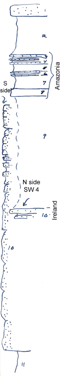
| Unit No. |
Description |
Thickness |
|
1
|
Sandstone, massive, brown
|
+ 3 ft.
|
|
2
|
Shale, gray, clayey
|
10 ft.
|
|
3
|
Limestone, platy, ferrug, chonetes & productids
|
0.3 ft.
|
|
4
|
Sandstone, rippled, fine, interbedded shale
|
1.5 ft.
|
|
5
|
Shale, silty, gray
|
2 ft.
|
|
6
|
Brown limestone in two layers, separated by shale, contains productids and chonetes
|
0.4 ft.
|
|
7
|
Shale, covered
|
3.5 ft.
|
|
8
|
Limestone, drab, largely composed to Triticites of oryziformis
|
2 ft.
|
|
9
|
Shale, gray (this seems to thin out where the Ireland is massive; probably is partly equivalent to Irelend)
|
+/- 30 ft.
|
|
10
|
Sandstone, massive ins S part of section, thin and shaly in U part of section
|
10 - 70 ft.
|
|
11
|
Bluish clay shale
|
|
|

