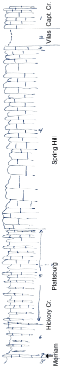
KGS Home

Geology Index Page

Wilson County

Sec. 26, T. 30 S., R. 15 E
Move to another county

Roadcuts
Measured By Newell, 8/1938
Exposures poor, intervals fairly accurate
 
Unit No. Description Thickness
1 Limestone, scarp-farmer, white, crystalline, basal bed bluish-gray, with algal "marklets" + 8 - 10 ft.
2 Shale, poorly shown, contains algal limestone near top 8 ft.
3 Limestone, buff, osagia-bearing 2 ft.
4 Limestone, heavy bedded, white, crystalline, not very fossiliferous 83 ft.
5 Limestone, very shaly, poorly shown, very fossiliferous, contains lots of sponges 45 ft.
6 Shale, gray, calcareous, with marly layers, many sponges, crinoids, brachiopods 14 ft.
7 Limestone, yellow, slabby, crinoidal, many sponges +/- 1 ft.
8 Shale, buff, silty, unfossiliferous  

Original Document

The Archive file you download contains a TIFF image compressed into a ZIP archive. Your browser may be already set up to decompress these files. Commercial software to perform this is available from PKWARE, Inc., the company that invented the format. A web page from a group of people creating shareware or public domain software is available at Info-ZIP. The TIFFs are 150-dpi archival-quality color scans of the original forms and can be viewed by software like Corel PhotoPaint or Adobe PhotoShop.


Kansas Geological Survey
Comments to webadmin@kgs.ku.edu
URL=http://www.kgs.ku.edu/General/Geology/Measured/index.html
Programs Updated May 2003