|
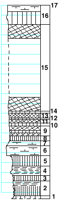
| Unit No. |
Description |
Thickness |
|
17
|
Florence limestone with flint bands
|
-- ft.
|
|
|
Blue Springs shale formation
|
|
|
16
|
Shale, green and mudstone
|
4 ft.
|
|
15
|
Shale, red, with few green bands
|
17.5 ft.
|
|
14
|
Shale, green
|
0.2 ft.
|
|
13
|
Shale, red
|
1 ft.
|
|
12
|
Shale, green
|
0.2 ft.
|
|
11
|
Shale, red
|
0.8 ft.
|
|
10
|
Shale, green
|
0.5 ft.
|
|
9
|
Shale, purple with green bands
|
2 ft.
|
|
8
|
Shale, dark-green
|
1 ft.
|
|
7
|
Mudstone, cavernous, green
|
1 ft.
|
|
6
|
Limestone, chalky, greenish-white, massive
|
2 ft.
|
|
5
|
Shale, dark-green, calcareous. Thin vein of calcite at the top.
|
2 ft.
|
|
4
|
Shale, finely banded, light-green
|
2 ft.
|
|
3
|
Shale, banded, green and black
|
1 ft.
|
|
2
|
Shale, black, massive
|
3 ft.
|
|
1
|
Shale, calcareous, with Derbyia
|
0.3 ft.
|
|

