|
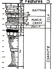
| Unit No. |
Description |
Thickness |
|
17
|
Limestone - shaly (and shale, very calcareou) light gray (N7), finely algal, flaky, actually composed of fine sized fossil fragments of crinoids, brachiopods, ramose bryozoans, fenestrate bryozoans, in a fine Osagia matrix
|
1.3 ft.
|
|
16
|
Limestone - hard, medium bedded (0.2 - 0.3 ft thick beds) grayish orange (10YR7/4), fossiliferous. Chonetes, Juresanis, Neospirifer, crinoid stems, fenestrate bryozoans, Hustedia, horn corals, ramose bryozoans
|
2.1 ft.
|
|
15
|
Shale - lenses out laterally, calcareous, fossiliferous, yellowish gray (5Y8/1)
|
0.1 ft.
|
|
14
|
Limestone - irregular, wavy bedded, grayish orange (10YR7/4) fossiliferous, crinoids and brachiopods
|
0.2 ft.
|
|
13
|
Shale - calcareous, fossiliferous, mainly crinoids and brachiopods, grayiwh orange (10YR7/4)
|
0.6 ft.
|
|
12
|
Limestone - irregular wavy bed, fossiliferous, mainly crinoids and brachiopods. Grayish orange (10YR7/4)
|
0.2 ft.
|
|
11
|
Shale - yellowish gray (5Y8/1), slightly silty, apparently unfossiliferous. Contains limestone nodules
|
0.5 ft.
|
|
10
|
Siltstone - hard, olive black (5Y2/1), carbonaceous and micaceous. Calcareous and contains calcareous nodules (may be corals)
|
0.5 ft.
|
|
9
|
Shale - grayish black (N2), fissile in lower 0.4 ft. Grades upward into olive gray (5Y4/1) micaceous wiltstone (0.1 ft. thick)
|
0.5 ft.
|
|
8
|
Shale - light olive gray (5Y6/1), calcareous, micaceous, apparently unfossiliferous
|
0.5 ft.
|
|
7
|
Limestone - hard, vertically jointed, medium gray (N5), dense fossiliferous. Crinoid stems, brachiopods fragments, Cryptozoan
|
0.2 ft.
|
|
6
|
Shale - calcareous, or limestone, very shaly, brownish gray (5YR4/1). Fossiliferous, mainly crinoidal remains
|
0.5 ft.
|
|
5
|
Limestone - medium light gray (N6), flaggy and unfossiliferous where it fills depressions, but laterally grades into a medium light gray (N6) very calcareous micaceous siltstone, slightly fossiliferous. Includes crinoid stems and brachiopod fragments
|
0.3 - 0.7 ft.
|
|
4
|
Shale - variable in color but generally light greenish gray (5GY8/1) with many ironstone concretions in it. Thickness very variable as limestone fills scours cur into shale
|
0.6 ft.
|
|
3
|
Coal - black, banded, more vitrain than dull. Bony in middle 1 inch and upper 1 inch
|
0.9 ft.
|
|
2
|
Claystone - medium dark gray (N4), non-silty. Underclay
|
0.5 ft.
|
|
1
|
Shale - light greenish gray (5GY8/1) to greenish gray (5GY6/1), fissile, slightly silty, finely micaceous. Contains a thin bed of very fine grained sandstone. Concretions about 8 ft. below top. Upper part poorly exposed.
|
12.3 ft.
|
|

