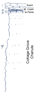
KGS Home

Geology Index Page

Wilson County

Sec. 6, T. 30 S., R. 17 E
Move to another county

Road exposure
Measured By Newell, 8/1938
Poor exposure
Unit No. Description Thickness
1 Limestone, thin-bedded, gray, irregular, poorly shown and probably originally somewhat thicker + 2 ft.
2 Shale, black, fissile, with phosphatic concretions, poorly shown +/- 1 ft.
3 Fine, brown limestone, with abundant brachiopods 0.4 ft.
4 Platy, fine, buff sandstone + 30 ft.

Original Document

The Archive file you download contains a TIFF image compressed into a ZIP archive. Your browser may be already set up to decompress these files. Commercial software to perform this is available from PKWARE, Inc., the company that invented the format. A web page from a group of people creating shareware or public domain software is available at Info-ZIP. The TIFFs are 150-dpi archival-quality color scans of the original forms and can be viewed by software like Corel PhotoPaint or Adobe PhotoShop.


Kansas Geological Survey
Comments to webadmin@kgs.ku.edu
URL=http://www.kgs.ku.edu/General/Geology/Measured/index.html
Programs Updated May 2003