|
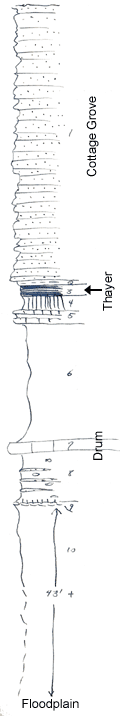
| Unit No. |
Description |
Thickness |
|
1
|
Sandstone, thin-bedded, fine, shalier near base, fossil plants in lower part, top eroded
|
+ 43 ft.
|
|
2
|
Shale, sandy, fossil ferns
|
0.7 ft.
|
|
3
|
Coal, in two beds with 1/2 inch gray clay at middle
|
0.1 ft.
|
|
4
|
Underclay, light gray
|
2.5 ft.
|
|
5
|
Marl, nodular, unfossiliferous, in two beds separated by shale (fresh water?)
|
2 ft.
|
|
6
|
Gray silty shale
|
17 ft.
|
|
7
|
Limestone, bluish-gray, blocky, fine, with abundant crinoid stems, Juresania symmetrica (characteristic of the Drum in this area), bryozoa
|
2 ft.
|
|
8
|
Shale, gray with buff siltstone beds (which probably become flaggy in the Charryvale area) and limonite concretions
|
6.5 ft.
|
|
9
|
Light gray underclay with carbonaceous streak at top, and underlain by one inch of brown, calcareous and ferrug concretionary rcok
|
0.4 ft.
|
|
10
|
Shale, gray, silty, base covered
|
+ 43 ft.
|
|

