Measured By J.M.J.
In August, 1936, while locating water supplies in this sandstone (Cottage Grove?) it was found to rest upon Stark shale in an exposure about 4 miles North of this section
|

|
|
|
| Unit No. |
Description |
Thickness |
|
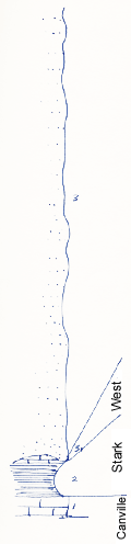
3
|
Sandstone - to top of hill to South
|
64.8 ft.
|
|
3-1
|
Fragments of West limestone in base of sandstone above, fragments +/- 3 ft long, several inches thick
|
|
|
2
|
Shale - Stark shale black fissile
|
3 - 4 ft.
|
|
1
|
Limestone - Canville - bluish - dense - fossiliferous
|
2.8 ft.
|
|
Original Document
The Archive file you download contains a TIFF image compressed into a ZIP archive.
Your browser may be already set up to decompress these files.
Commercial software to perform this is available from
PKWARE, Inc., the company that invented the format.
A web page from a group of people creating shareware or public
domain software is available at Info-ZIP.
The TIFFs are 150-dpi archival-quality color scans of the original forms and can be viewed by software like Corel PhotoPaint or Adobe PhotoShop.
|