|
| Unit No. |
Description |
Thickness |
|
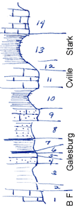
14
|
Limestone, gray crystalline, thin to massive beds, ireregular beds, many fossils, much more exposed near by - lower part of Winterset limestone
|
4 ft.
|
|
13
|
Shale, very black thin bedded and fissile
|
5 ft.
|
|
12
|
Covered interval
|
0.4 ft.
|
|
11
|
Limestone, light gray, crystalline
|
2 - 3 ft.
|
|
10
|
Shale, yellow, fossiliferous, calcareous
|
+/- 3 ft.
|
|
9
|
Sandstone
|
+/- 2 ft.
|
|
8
|
Sandy shale and sandstone, 0.1 ft coal at base
|
3 ft.
|
|
7
|
Shale, dark gray
|
2 ft.
|
|
6
|
Coal
|
0.2 ft.
|
|
5
|
Shale, dark
|
0.3 ft.
|
|
4
|
Sandstone, gray, soft
|
1 ft.
|
|
3
|
Shale, clay
|
2.6 ft.
|
|
2
|
Covered interval
|
1.5 ft.
|
|
1
|
Limestone, blue, granular, sub-oolitic at top, oolitic at base of exposure, to water in creek - B. Falls
|
2 ft.
|
|