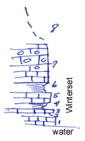
KGS Home

Geology Index Page

Neosho County

Sec. 11, T. 28 S., R. 18 E
Move to another county

Old dam site South of bridge over Neosho River
Measured By J.M. Jewett
Refer to Section A66
 
Unit No. Description Thickness
8 Covered slope  
7 Limestone, light in color, fairly massive, chert, fusulinids, marginiferas, pelecypods, irregular beds, exposed 5 ft.
6 Shale and thin, irregular limestone beds 1.7 ft.
5 Limestone, light in color, massive, in two or three beds 1.6 ft.
4 Shale 0.35 ft.
3 Limestone 0.1 ft.
2 Shale, gray, calcareous 0.4 ft.
1 Limestone, light blue to gray, massive, highly crystalline, exposed 2 ft.
  Note this is near top of Winterset limestone  

Original Document

The Archive file you download contains a TIFF image compressed into a ZIP archive. Your browser may be already set up to decompress these files. Commercial software to perform this is available from PKWARE, Inc., the company that invented the format. A web page from a group of people creating shareware or public domain software is available at Info-ZIP. The TIFFs are 150-dpi archival-quality color scans of the original forms and can be viewed by software like Corel PhotoPaint or Adobe PhotoShop.


Kansas Geological Survey
Comments to webadmin@kgs.ku.edu
URL=http://www.kgs.ku.edu/General/Geology/Measured/index.html
Programs Updated May 2003