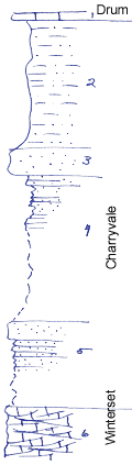
River bed and road cuts
Measured By Newell, 8/1935
Record started at the center of section 3 and continues south into section 10
|

|
|
|
| Unit No. |
Description |
Thickness |
|
1
|
Drum limestone
|
|
|
2
|
Silty, light buff shale
|
15 ft.
|
|
3
|
Massive sandstone
|
3 ft.
|
|
4
|
Platy sandstone above, covered below
|
17 ft.
|
|
5
|
Platy & massive sandstone, covered below
|
10 ft.
|
|
6
|
Drab, cross bedded, coquinoid limestone
|
+ 5 ft.
|
|
Original Document
The Archive file you download contains a TIFF image compressed into a ZIP archive.
Your browser may be already set up to decompress these files.
Commercial software to perform this is available from
PKWARE, Inc., the company that invented the format.
A web page from a group of people creating shareware or public
domain software is available at Info-ZIP.
The TIFFs are 150-dpi archival-quality color scans of the original forms and can be viewed by software like Corel PhotoPaint or Adobe PhotoShop.
|