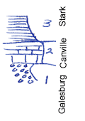
KGS Home

Geology Index Page

Neosho County

Sec. 8, T. 28 S., R. 19 E
Move to another county

Just above water level of Neosho river. Canville limestone dips under river a few yards west of this exposure
Measured By J.M. Jewett, 7/22/1931
Refer to notebook no. A 33
Unit No. Description Thickness
3 Shale, black +/- 3 ft.
2 Limestone, somewhat earthy, yet crystalline 2.5 ft.
1 Sandstone, gray, micaceous, to water of Neosho river, exposed +/- 2 ft.
  Note: this is near site of an old ford which was formerly on Canville limestone  

Original Document

The Archive file you download contains a TIFF image compressed into a ZIP archive. Your browser may be already set up to decompress these files. Commercial software to perform this is available from PKWARE, Inc., the company that invented the format. A web page from a group of people creating shareware or public domain software is available at Info-ZIP. The TIFFs are 150-dpi archival-quality color scans of the original forms and can be viewed by software like Corel PhotoPaint or Adobe PhotoShop.


Kansas Geological Survey
Comments to webadmin@kgs.ku.edu
URL=http://www.kgs.ku.edu/General/Geology/Measured/index.html
Programs Updated May 2003