|
| Unit No. |
Description |
Thickness |
|
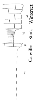
4
|
Winterset limestone, makes cliff 10 ft. high, holds hills far to west
|
|
|
3
|
Black shale, not well seen
|
+/- 6 ft.
|
|
2
|
Massive, brown-gray crystalline limestone (Probably only bed 2 in 4-29-19e) rest of Canville not seen in 3
|
+/- 1 ft.
|
|
1
|
Covered, some sandy shale
|
+/- 20 ft.
|
|