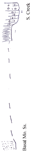
KGS Home

Geology Index Page

Neosho County

Sec. 8, T. 28 S., R. 21 E
Move to another county

Measured By J.M. Jewett, 7/31/1935
C 128
Unit No. Description Thickness
2 Mass of chert, some unweathered limestone, mostly dense and blue, with irregular chert nodules, few brachiopods +/- 10 ft.
1 Shale, not well exposed  
  +/- 30 ft. below is bench of transported chert, then +/- 30 ft. below is plain of chert gravel, which nearly coincides with sandstone.  
  Note; Exposure NW 10-28-21 shows about same. (Science Hill School)  
  Valleys in this area have been re-excavated after having been filled with chert (Tertiary?)  

Original Document

The Archive file you download contains a TIFF image compressed into a ZIP archive. Your browser may be already set up to decompress these files. Commercial software to perform this is available from PKWARE, Inc., the company that invented the format. A web page from a group of people creating shareware or public domain software is available at Info-ZIP. The TIFFs are 150-dpi archival-quality color scans of the original forms and can be viewed by software like Corel PhotoPaint or Adobe PhotoShop.


Kansas Geological Survey
Comments to webadmin@kgs.ku.edu
URL=http://www.kgs.ku.edu/General/Geology/Measured/index.html
Programs Updated May 2003