|
| Unit No. |
Description |
Thickness |
|
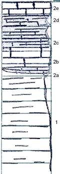
1
|
Shale, gray to blue-gray, altered at top to drab and brown. Thinly but evenly bedded. Silty in certain beds. Uppermost part is limey and contains some limestone concretions or nodules
|
7.5 ft.
|
|
2
|
Limestone (in 5 distinct beds)
|
|
|
2a
|
Limestone, slabby to nodular, does not have constant thickness
|
0 - 5 ft.
|
|
2b
|
Limestone, gray, weathers lighter. Dense, forms single bed. Fossiliferous, but fossils do not occur in abundance, nor are they easily collected--Productids, crinoids, Composita, Ambocoelia
|
1.5 ft.
|
|
2c
|
Limestone, very nodular, nodules dissaggregate upon weathering. Apparently are very thoroughly intersticed with clayey material. Portions weather to slabby limestone before becoming completely dissaggregated. Nodules vary from 1 - 6 inches in greatest diameter
|
1.83 ft.
|
|
2d
|
Calcareous shale, drab in color
|
1.83 ft.
|
|
2e
|
Limestone, hard, gray. Has same fossils as does bed 2b
|
1.17 ft.
|
|
3
|
Soil
|
+ 1 ft.
|
|


