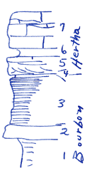
KGS Home

Geology Index Page

Neosho County

Sec. 20, T. 29 S., R. 20 E
Move to another county

2 miles N of Hertha, Ks.
Measured By J.M. Jewett, 1939
Restudy of Type Hertha
Unit No. Description Thickness
7 Limestone, light to dark gray, massive to thin irregular beds; some beds up to 1.5 ft., full of "marklet" like calcite veins, mottled, few brachiopods 6 ft.
6 Shale: upper 0.5 ft. gray, silty, fossils; lower 1.1 ft. dark to black, silty; fossils more abundant in upper 0.5 ft. than in lower 1.1 ft. 1.6 ft.
5 Mudstone, laminated, hard, dark blue-gray, cross bedded in lower part 2.4 ft.
4 Shale, gray, silty 0.25 ft.
3 Shale, black platy 8.3 ft.
2 Mudstone, hard, dark, dense, variable thickness, "flags" of Bourbon and southern Linn Co. +/- 2.2 ft.
1 Shale gray, silty +/- flaky  
  See photograph - J.M.J.  

Original Document

The Archive file you download contains a TIFF image compressed into a ZIP archive. Your browser may be already set up to decompress these files. Commercial software to perform this is available from PKWARE, Inc., the company that invented the format. A web page from a group of people creating shareware or public domain software is available at Info-ZIP. The TIFFs are 150-dpi archival-quality color scans of the original forms and can be viewed by software like Corel PhotoPaint or Adobe PhotoShop.


Kansas Geological Survey
Comments to webadmin@kgs.ku.edu
URL=http://www.kgs.ku.edu/General/Geology/Measured/index.html
Programs Updated May 2003