|
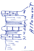
| Unit No. |
Description |
Thickness |
|
|
Limestone, light gray, crystalline, brachiopods, characteristic upper Alt of Linn Co. (not full thickness)
|
1.5 ft.
|
|
|
Shale, gray to yellow, +/- flacky
|
+/- 3 ft.
|
|
|
Shale, black fissile, phosphatic nodules, short teeth and bones
|
+/- 1 ft.
|
|
|
Shale, gray, light
|
+/- 1 ft.
|
|
|
Limestone, upper surface nodular, algal like, brachiopods mostly as fragments, medium gray weathers slightly brown, Hoag?
|
1.3 ft.
|
|
|
Shale, black
|
2 ft.
|
|
|
Limestone, thin beds, irregular beds, medium gray, less crystalline than above, nodular irregular upper surface. Few crystal faces, mostly dense & slightly darker than 1.3 limestone above; definite but slightly irregular base
|
2 ft.
|
|
|
Shale, gray, clay, limonitic, slightly blocky
|
3 ft.
|
|
|
Slope covered by limestone debris from above
|
|
|
|
Note: Altamont in this area is thicker than indicated by this section as all upper is not present. Bandera below makes sandy soil.
|
|
|