|
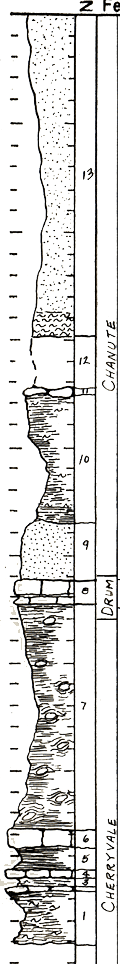
| Unit No. |
Description |
Thickness |
|
13
|
Sandstone - very pale orange (10YR8/2) to pale reddish brown (10R5/4) with light siltstone at base. Poorly exposed, caps hill
|
30 ft.
|
|
12
|
Covered interval - probably shale and coal
|
5 ft.
|
|
11
|
Limestone - marly, pale yellowish orange (10YR8/6), unfossiliferous, nodular
|
0.4 ft.
|
|
10
|
Shale - light olive gray (5Y6/1), slightly silty, poorly exposed
|
12 ft.
|
|
9
|
Sandstone - yellowish gray (5Y7/2) to pale red (5R6/2) very fine grained, micaceous, plant fragments, worm tracks friable poorly exposed
|
5 ft.
|
|
8
|
Limestone - light brownish gray (5YR6/1) fresh, light gray (N7) to grayish orange (10YR7/4) weathered, osagia profuse, also Neosporifer, crinoids stems, fenestrate bryozoan horn corals, Cryptozoon. Hard, vertically jointed
|
2 ft.
|
|
7
|
Shale - poorly exposed, apparently has many ironstone concretions
|
21.4 ft.
|
|
6
|
Limestone - medium light gray (N6) fresh, moderate yellowish brown (10YR5/4) weathered, very fossiliferous, contains abundant Cryptozoon, and also horn corals, fenestrate bryozoan, Derbyia, Composita, Osagia (small)
|
1.5 ft.
|
|
5
|
Shale - yellowish gray (5Y7/2), practically non silty, unfossiliferous
|
2 ft.
|
|
4
|
Limestone - light gray (N7) fresh, yellowish orange (10YR7/6) weathered, hard, vertically jointed, very fine crystalline, dense, unfossiliferous
|
0.5 ft.
|
|
3
|
Shale - yellowish gray (5Y7/2), very slightly silty, finely micaceous, unfossiliferous
|
0.9 ft.
|
|
2
|
Limestone - brownish orange (10YR7/3), unfossliferous and breaks into thin flakes
|
0.15 ft.
|
|
1
|
Shale - yellowish gray, slightly silty, micaceous, unfossiliferous
|
5 ft.
|
|
|
Limestone #6 appears to be out of place somehow - This section should be field checked before used or the data relied upon. I suspect that #6 and #8 are the same. H.C.W.
|
|
|