KGS Home

Geology Index Page

Neosho County

Sec. 12, T. 30 S., R. 20 E
Move to another county

0.2 miles W of SE corner section
Measured By
Unit No. Description Thickness
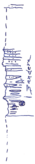
  Altamont limestone, bench  
  Covered 16 ft.
  Sandstone, ripple marked, +/- massive beds, as "younger Bandera" of Bourbon co. +/- 6 ft.
  Sandstone and shale, sandstone largely in rounded pockets & some in thin beds +/- 12 ft.
  Shale, blocky, clayey, drab gray, concretionary like clay masses, slightly limonitic +/- 1 ft. in diameter +/- 7 ft.
  Covered to flood plain of Neosho river 16 ft.

Original Document

The Archive file you download contains a TIFF image compressed into a ZIP archive. Your browser may be already set up to decompress these files. Commercial software to perform this is available from PKWARE, Inc., the company that invented the format. A web page from a group of people creating shareware or public domain software is available at Info-ZIP. The TIFFs are 150-dpi archival-quality color scans of the original forms and can be viewed by software like Corel PhotoPaint or Adobe PhotoShop.


Kansas Geological Survey
Comments to webadmin@kgs.ku.edu
URL=http://www.kgs.ku.edu/General/Geology/Measured/index.html
Programs Updated May 2003