|
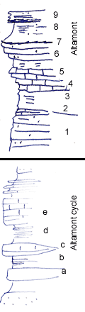
| Unit No. |
Description |
Thickness |
|
9
|
Upper Altamont, weathered
|
? ft.
|
|
8
|
Shale, poorly seen, some black phosphatic concretion
|
? ft.
|
|
7
|
Limestone, irregular top, granular fossil fragments, thin beds, gray
|
+/- 1 ft.
|
|
6
|
Shale, gray & flaky
|
|
|
5
|
Limestone; light color, +/- massive, light gray, slightly crystalline, many crinoid fragments in upper part, weathers nodular & brecciated
|
+/- 4 ft.
|
|
4
|
Slight shale break
|
? ft.
|
|
3
|
Limestone, light gray; crystalline, thin bedded, shaly, def but irregular contact below
|
1 ft.
|
|
2
|
Shale, gray-yellow limonitic
|
+/- 4 ft.
|
|
1
|
Sandstone, thin bedded, shaly, buff, part massive, fine grained, micaceous, laminated
|
+/- 6 ft.
|
|
|
Description for lower section: Altamont is thicker in this areal than this section indicates, as full thickness of upper not seen. Bandera makes sandy soil below
|
|
|