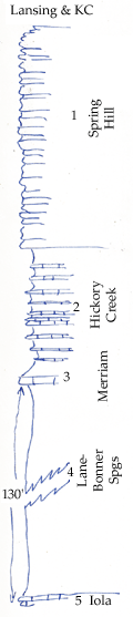
KGS Home

Geology Index Page

Montgomery County

Sec. 12, T. 31 S., R. 15 E
Move to another county

Measured By Newell, 8/1938
 
Unit No. Description Thickness
1 Limestone yellow below, white above, top not shown, has many fossil sponges in lower part + 70 ft.
2 Shale and interbedded limestone, filled with fossil sponges 40 ft.
3 Limestone, yellow, irregular, many sponges 2.5 ft.
4 Shale, gray, silty, unfossiliferous 130 ft.
5 Limestone, poorly shown  

Original Document

The Archive file you download contains a TIFF image compressed into a ZIP archive. Your browser may be already set up to decompress these files. Commercial software to perform this is available from PKWARE, Inc., the company that invented the format. A web page from a group of people creating shareware or public domain software is available at Info-ZIP. The TIFFs are 150-dpi archival-quality color scans of the original forms and can be viewed by software like Corel PhotoPaint or Adobe PhotoShop.


Kansas Geological Survey
Comments to webadmin@kgs.ku.edu
URL=http://www.kgs.ku.edu/General/Geology/Measured/index.html
Programs Updated May 2003