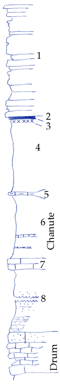
KGS Home

Geology Index Page

Montgomery County

Sec. 34, T. 31 S., R. 16 E
Move to another county

Measured By Newell, 8/1935
Roadcuts
 
Unit No. Description Thickness
1 Platy buff sandstone + 31 ft.
2 Coal 0.3 ft.
3 Underclay 0.5 ft.
4 Gray clay shale 18 ft.
5 Yellow nodular silty limestone, non-fossiliferous +/- 1 ft.
6 Gray clay shale with thin platy crinoidal limestone 17 ft.
7 Bluish-gray crinoidal limestone, fine grained, hard contains Echinocadius 2.5 ft.
8 Silty shale and rippled sandstone 37 ft.
9 Massive granular molluscan limestone 3 ft.
10 Crystalline to fine irregular light gray limestone (cement city) 8 ft.
11 Shell  

Original Document

The Archive file you download contains a TIFF image compressed into a ZIP archive. Your browser may be already set up to decompress these files. Commercial software to perform this is available from PKWARE, Inc., the company that invented the format. A web page from a group of people creating shareware or public domain software is available at Info-ZIP. The TIFFs are 150-dpi archival-quality color scans of the original forms and can be viewed by software like Corel PhotoPaint or Adobe PhotoShop.


Kansas Geological Survey
Comments to webadmin@kgs.ku.edu
URL=http://www.kgs.ku.edu/General/Geology/Measured/index.html
Programs Updated May 2003