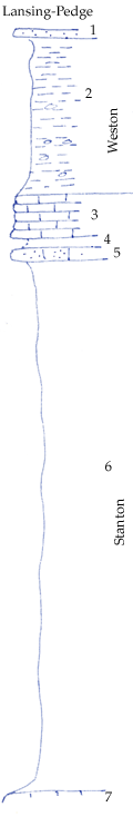
KGS Home

Geology Index Page

Montgomery County

Sec. 23, T. 32 S., R. 14 E
Move to another county

Road exposures
Measured By Newell, 8/1935
Fine fossil collecting 200 yards north of road along hill wash in Eudora shale
Unit No. Description Thickness
1 Blocky brown sandstone, persistant (appears to overlap #2 eastward in this region and becomes massive) 1 ft.
2 Bluish clay shale with limonite concretions, contains Trepospira sphaerulata and Nuculana bellistriata 18 ft.
3 Gray, sparsely fossiliferous, fine crinoidal limestone 4.5 ft.
4 Shale break, not show, not over 1 ft.
5 Massive brown oolite, hard 1.5 ft.
6 Gray clay shale, contains fossils in upper 1/3 possibly in lower part too; small Myalina cf. subquodratea, crinoid stems, Composita, bellerophontids, Productids, Neospirifer, Fistulifora + 60 ft.
7 Brown limestone with sponges  

Original Document

The Archive file you download contains a TIFF image compressed into a ZIP archive. Your browser may be already set up to decompress these files. Commercial software to perform this is available from PKWARE, Inc., the company that invented the format. A web page from a group of people creating shareware or public domain software is available at Info-ZIP. The TIFFs are 150-dpi archival-quality color scans of the original forms and can be viewed by software like Corel PhotoPaint or Adobe PhotoShop.


Kansas Geological Survey
Comments to webadmin@kgs.ku.edu
URL=http://www.kgs.ku.edu/General/Geology/Measured/index.html
Programs Updated May 2003