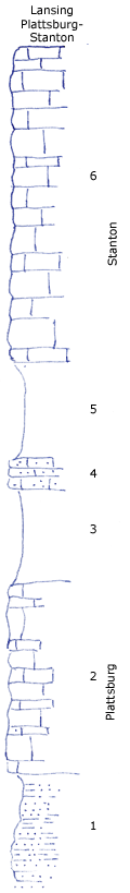
KGS Home

Geology Index Page

Montgomery County

Sec. 20, T. 32 S., R. 14 E
Move to another county

On Elk City--Independence highway 3 miles southeast of Elk City at Elk River bridge and vicinity.
Measured By R.C. M. 470, 7/17/1931
 
Unit No. Description Thickness
6 Limestone gray, oolite and "oatmeal" at the top, slabby bluish below 33 ft.
5 Shale blue clay with abundant fossils, especially crinoid stems 10 ft.
4 Limestone, bluish sandy makes bench +/- 3 ft.
3 Shale bluish gray with molluscan fauna, Trepospira, Worthenia Astartella Bellerophon Ambocoelia +/- 10 ft.
2 Limestone light gray massive +/- 20 ft.
1 Shale, dark bluish sandy and limy impure platy sandstone + 20 ft.

Original Document

The Archive file you download contains a TIFF image compressed into a ZIP archive. Your browser may be already set up to decompress these files. Commercial software to perform this is available from PKWARE, Inc., the company that invented the format. A web page from a group of people creating shareware or public domain software is available at Info-ZIP. The TIFFs are 150-dpi archival-quality color scans of the original forms and can be viewed by software like Corel PhotoPaint or Adobe PhotoShop.


Kansas Geological Survey
Comments to webadmin@kgs.ku.edu
URL=http://www.kgs.ku.edu/General/Geology/Measured/index.html
Programs Updated May 2003