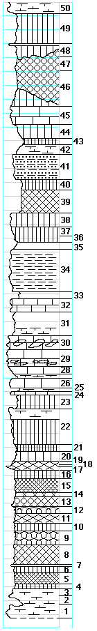
|
| Unit No. |
Description |
Thickness |
|
|
Middleburg limestone member
|
|
|
50
|
Limestone, splittery, with Pseudomonotis, Aviculopecten, Juresania, and Septopora
|
1.5 ft.
|
|
|
Hooser shale member
|
|
|
49
|
Shale, green
|
4.5 ft.
|
|
48
|
Shale, green, massive, laminated
|
2 ft.
|
|
47
|
Shale, maroon, splittery
|
2 ft.
|
|
46
|
Shale, red
|
5 ft.
|
|
|
Eiss limestone member
|
|
|
45
|
Limestone, banded, tough, cavernous, yellow-gray
|
2.7 ft.
|
|
44
|
'Boxwork,' green
|
2 ft.
|
|
43
|
Shale, green, Chonetes near the base
|
0.8 ft.
|
|
42
|
Mudstone, green, with crinoid joints, bryozoa (Meekopora and others), Chonetes, and Composita
|
1.5 ft.
|
|
|
Stine shale formation
|
|
|
41
|
Mudstone, harder than the bed above, green, fine, sandy, banded, anbd splittery
|
3.5 ft.
|
|
40
|
Shale, dark-green
|
3.5 ft.
|
|
39
|
Shale, purple, with blue-green spots
|
3.5 ft.
|
|
38
|
Shale, calcareous, massive, light-green
|
2 ft.
|
|
37
|
Shale, calcareous, splittery
|
1 ft.
|
|
36
|
Shale, splittery
|
1 ft.
|
|
35
|
Shale, yellowish, calcareous
|
1 ft.
|
|
34
|
Mudstone, gray, calcareous, banded to laminated
|
6 ft.
|
|
33
|
Shale, yellowish
|
1 ft.
|
|
|
Morrill limestone member
|
|
|
32
|
Mudstone, blue-gray, massive, fossiliferous
|
2 ft.
|
|
|
Florena shale member
|
|
|
31
|
Shale, blue-gray, calcareous, fossiliferous
|
3.1 ft.
|
|
|
Cottonwood limestone member
|
|
|
30
|
Limestone, massive, with fusulinids and a band of cherty concretions in the middle
|
2 ft.
|
|
29
|
Limestone, massive, fusulinids in the upper 1 foot, two bands of cherty concretions in the lower 1.4 feet.
|
2.4 ft.
|
|
28
|
Limestone, slightly softer than the beds above, massive
|
1 ft.
|
|
27
|
Mudstone, splittery
|
0.5 ft.
|
|
26
|
Limestone, massive, with few Chonetes
|
1.5 ft.
|
|
25
|
Mudstone, splittery
|
0.5 ft.
|
|
24
|
Mudstone, solid
|
0.5 ft.
|
|
|
Eskridge shale formation
|
|
|
23
|
Shale, green
|
2 ft.
|
|
22
|
Mudstone, green, splittery; in a bed 3 feet below the top occurs Pseudomonotis, Aviculopecten, Juresania
|
5 ft.
|
|
21
|
Shale, dark, green-blue
|
1 ft.
|
|
20
|
Shale, light-green
|
1..5 ft.
|
|
19
|
Shale, light-purple
|
0.5 ft.
|
|
18
|
Limestone
|
0.1 ft.
|
|
17
|
Shale, light-purple
|
0.7 ft.
|
|
16
|
Shale, green
|
1.2 ft.
|
|
15
|
Shale, red
|
2 ft.
|
|
14
|
Shale, purple
|
0.5 ft.
|
|
13
|
Mudstone, green
|
1.5 ft.
|
|
12
|
Shale, purple and blue-green
|
1 ft.
|
|
11
|
Shale, purple
|
1.5 ft.
|
|
10
|
Shale, green
|
1 ft.
|
|
9
|
Shale, purple and dark-green
|
2 ft.
|
|
8
|
Shale, green
|
0.9 ft.
|
|
7
|
Shale, red
|
1.8 ft.
|
|
6
|
Shale, green
|
0.4 ft.
|
|
5
|
Shale, red
|
1.8 ft.
|
|
4
|
Shale, green
|
0.4 ft.
|
|
|
Neva limestone formation
|
|
|
3
|
Mudstone, gray, canvernous
|
0.8 ft.
|
|
2
|
Shale, calcareous, splittery
|
1 ft.
|
|
1
|
Mudstone, massive, with echinoid spines
|
2+ ft.
|
|

