|
| Unit No. |
Description |
Thickness |
|
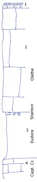
1
|
Oolitic fossiliferous sandstone float, estimeted at
|
+ 2 ft.
|
|
2
|
Very massive cliff forming limestone; in artificial cuts appears thin bedded and wavy; bluish, crystalline, few fossils other than scattered crinoid stems measured in cliff NW of bridge
|
40 ft.
|
|
3
|
Clay shale, somewhat limy with abundant crinoid stems, chonetina, Lissochonetes, Rhipidomella, etc; nodular at top; measured just South of bridge
|
18 ft.
|
|
4
|
Limestone, contains a few sponges, Triticites, Enteletes (Girtycoelia beiyamini, Heliospongia ramosa.
|
|
|

