|
| Unit No. |
Description |
Thickness |
|
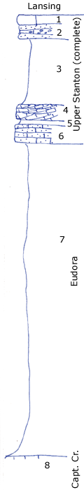
1
|
Massive, light gray limestone oolite and dense limestone
|
2 ft.
|
|
2
|
Coarse brown sandstone and limestone conglomerate
|
3 ft.
|
|
3
|
Gray clay shale with Hypselentoma, Naticopsis, etc.
|
13 ft.
|
|
4
|
Gray conglomeratic oolite coquinoid, has fusulinids in a shaly break (seen at quarry)
|
3 ft.
|
|
5
|
Light gray limy shale
|
0.8 ft.
|
|
6
|
Buff siltstone with crinoid stems, very limy
|
3.5 ft.
|
|
7
|
Clay shale, poorly shown
|
+/- 60 ft.
|
|
8
|
Limestone
|
|
|
