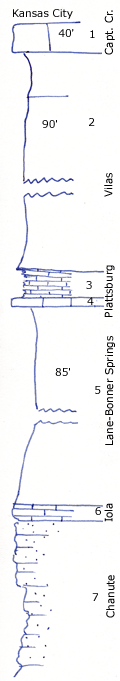
KGS Home

Geology Index Page

Montgomery County

Sec. 10, T. 32 S., R. 15 E
Move to another county

Northeast corner of Table Mound NW of Independence, Kansas
Measured By Newell, 8/1935
 
Unit No. Description Thickness
1 Massive crystalline white limestone with Enteletes 40 ft.
2 Covered shale (Vilas) 90 ft.
3 Nodular yellow shale with sponges, well show at shale pit SW corner Table Mound 3 ft.
4 Brown, blocky limestone with sponges, probably Merriam member, well shown at shale pit SW corner Table Mound 1.5 ft.
5 Silty gray shale, well shown at shale pit, SW corner Table Mound +/- 85 ft.
6 Fine-grained, brown, blocky limestone with Marginifera, poorly shown +/- 2 ft.
7 Flaggy buff sandstone seen along River +/- 20 ft.
  7/32/15 Olathe limestone is 40 ft. thick.  

Original Document

The Archive file you download contains a TIFF image compressed into a ZIP archive. Your browser may be already set up to decompress these files. Commercial software to perform this is available from PKWARE, Inc., the company that invented the format. A web page from a group of people creating shareware or public domain software is available at Info-ZIP. The TIFFs are 150-dpi archival-quality color scans of the original forms and can be viewed by software like Corel PhotoPaint or Adobe PhotoShop.


Kansas Geological Survey
Comments to webadmin@kgs.ku.edu
URL=http://www.kgs.ku.edu/General/Geology/Measured/index.html
Programs Updated May 2003