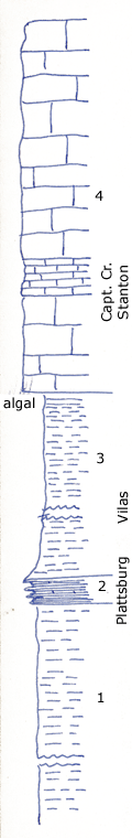
Old quarry of Atlas Portland Cement Co NW of Independence, Kansas on Table Mound
Measured By Newell/LeHunt
Including section by Schroeder.
|
|
|
|
| Unit No. |
Description |
Thickness |
|
4
|
Heavy-bedded coarsely crystalline whitish limestone with limonite inclusions; Enteletes pugnoides and Marginifera wabashensis common
|
44 ft.
|
|
3
|
Gray sandy and silty shale with algal heads at top
|
80 ft.
|
|
2
|
Yellow shaly limestone with Heterocoelia beedei and other sponges common
|
3 ft.
|
|
1
|
Clay shale base covered
|
+ 40 ft.
|
|
Original Document
The Archive file you download contains a TIFF image compressed into a ZIP archive.
Your browser may be already set up to decompress these files.
Commercial software to perform this is available from
PKWARE, Inc., the company that invented the format.
A web page from a group of people creating shareware or public
domain software is available at Info-ZIP.
The TIFFs are 150-dpi archival-quality color scans of the original forms and can be viewed by software like Corel PhotoPaint or Adobe PhotoShop.
|
