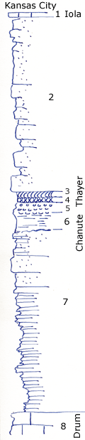
Lakeside Park, north Independence, Kansas, river drive.
Measured By Newell, 8/1935
|
|
|
|
| Unit No. |
Description |
Thickness |
|
1
|
Iola, blocky limestone remnant seen at cemetary
|
|
|
2
|
Massive cross-bedded slabby sandstone, streaks of reworked coal in lower part; contains white specks look like chert grains; clay balls at base
|
35 ft.
|
|
3
|
Coal
|
1 ft.
|
|
4
|
Underclay, yellowish-gray
|
0.7 ft.
|
|
5
|
Brown nodular shale
|
2 ft.
|
|
6
|
Silty buff shale
|
4 ft.
|
|
7
|
Platy riffled sandstone shaly below and above, layer of ronstone concretions at top
|
36 ft.
|
|
8
|
Massive oolite
|
|
|
Original Document
The Archive file you download contains a TIFF image compressed into a ZIP archive.
Your browser may be already set up to decompress these files.
Commercial software to perform this is available from
PKWARE, Inc., the company that invented the format.
A web page from a group of people creating shareware or public
domain software is available at Info-ZIP.
The TIFFs are 150-dpi archival-quality color scans of the original forms and can be viewed by software like Corel PhotoPaint or Adobe PhotoShop.
|
