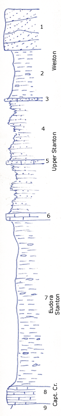
KGS Home

Geology Index Page

Montgomery County

Sec. 24, T. 33 S., R. 14 E
Move to another county

West of Bolton
Measured By Newell, 8/1935
Upper limestone beds probably correlate with "Buxton" limestone at Caney
Unit No. Description Thickness
1 Massive cross-bedded sandstone + 10 ft.
2 Covered clay shale 12 ft.
3 Brown sandy oolite, contains Composita, bellerophonitids, bryozoa, Neospirifer, Linoproductus 0.6 ft.
4 Clayey and papery sandy shale 15 ft.
5 Platy, sandy, brown oolite with some fossils as above 1 ft.
6 Buff crinoidal limestone, rather medium grained 1.5 ft.
7 Bluish clay shale with ammonites, Phanerotema grayvillence, crinoid stems, etc., Trepospira poorly shown +/- 40 ft.
8 (Seen in creek bed NW corner 24) 4 foot yellow shaly limestone with abundant fossil sponges, particularly Coelocladia spinosa, Heliospongia ramosa, Girtyocoelia beedei, etc. +/- 4 ft.

Original Document

The Archive file you download contains a TIFF image compressed into a ZIP archive. Your browser may be already set up to decompress these files. Commercial software to perform this is available from PKWARE, Inc., the company that invented the format. A web page from a group of people creating shareware or public domain software is available at Info-ZIP. The TIFFs are 150-dpi archival-quality color scans of the original forms and can be viewed by software like Corel PhotoPaint or Adobe PhotoShop.


Kansas Geological Survey
Comments to webadmin@kgs.ku.edu
URL=http://www.kgs.ku.edu/General/Geology/Measured/index.html
Programs Updated May 2003