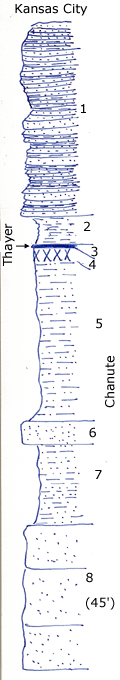
Roadcuts and creek
Measured By Newell, 7/1935
|

|
|
|
| Unit No. |
Description |
Thickness |
|
1
|
Platy sandstone with a little interbedded shale, the Iola horizon is not more than 8 or 10 ft. above this, probably less
|
+ 27 ft.
|
|
2
|
Sandy, profery shale
|
4 ft.
|
|
3
|
Coal (Thayer)
|
0.5 ft.
|
|
4
|
Whitish underclay
|
2 ft.
|
|
5
|
Silty and sandy gray shale
|
22 ft.
|
|
6
|
Hard massive sandstone wabesbench
|
3 ft.
|
|
7
|
Buff sandy shale. O shaly sandstone
|
11 ft.
|
|
8
|
Massive buff soft sandstone bore covered (No. 8 is about 45 ft. thick at C.E. side 19-33-16)
|
+ 20 ft.
|
|
Original Document
The Archive file you download contains a TIFF image compressed into a ZIP archive.
Your browser may be already set up to decompress these files.
Commercial software to perform this is available from
PKWARE, Inc., the company that invented the format.
A web page from a group of people creating shareware or public
domain software is available at Info-ZIP.
The TIFFs are 150-dpi archival-quality color scans of the original forms and can be viewed by software like Corel PhotoPaint or Adobe PhotoShop.
|
