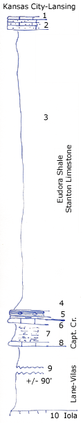
KGS Home

Geology Index Page

Montgomery County

Sec. 5, T. 33 S., R. 15 E
Move to another county

North slope Walker Mound
Measured By Newell
Upper limestone erroneously mapped Independence folio as younger than Stanton.
Unit No. Description Thickness
1 Silty light gray limestone remnant + 0.6 ft.
2 Buff very limy siltstone 3 ft.
3 Clay shale, poorly shown, abundant Eupheimtes in upper part, crinoid segments abundant near base 70 ft.
4 Black, fissile shale with phosphatic concretions +/- 2 ft.
5 Gray shale with Lophophyllum 0.5 ft.
6 Blocky, bluish limestone, filled with Coelocldia, Heliospongia, Girtyocoelia beedei, Cryptozoan, a typical Plattsburg sponge fauna 1 ft.
7 Very marly shale, slightly fossiliferous 4.5 ft.
8 Rounded, massive, bluish oolite, hard 1.5 ft.
9 Clay shale with limonite concretions +/- 90 ft.
10 Iola plain (computed from regional dip on topographic map)  

Original Document

The Archive file you download contains a TIFF image compressed into a ZIP archive. Your browser may be already set up to decompress these files. Commercial software to perform this is available from PKWARE, Inc., the company that invented the format. A web page from a group of people creating shareware or public domain software is available at Info-ZIP. The TIFFs are 150-dpi archival-quality color scans of the original forms and can be viewed by software like Corel PhotoPaint or Adobe PhotoShop.


Kansas Geological Survey
Comments to webadmin@kgs.ku.edu
URL=http://www.kgs.ku.edu/General/Geology/Measured/index.html
Programs Updated May 2003