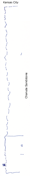
Center of section measured up scarp from east side.
Measured By Newell, 7/1935
|

|
|
|
| Unit No. |
Description |
Thickness |
|
1
|
Covered sandstone and shale, the upper part makes bench which is top of 45 foot sandstone 1/2 mile West lower part is blocky sandstone in sandy shale
|
70 ft.
|
|
2
|
Massive buff sandstone (only 10 feet exposed, 20 feet at center of NE1/4)
|
20 ft.
|
|
Original Document
The Archive file you download contains a TIFF image compressed into a ZIP archive.
Your browser may be already set up to decompress these files.
Commercial software to perform this is available from
PKWARE, Inc., the company that invented the format.
A web page from a group of people creating shareware or public
domain software is available at Info-ZIP.
The TIFFs are 150-dpi archival-quality color scans of the original forms and can be viewed by software like Corel PhotoPaint or Adobe PhotoShop.
|
