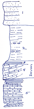
KGS Home

Geology Index Page

Montgomery County

Sec. 29, T. 33 S., R. 16 E
Move to another county

Measured By Newell, 7/1935
Unit No. Description Thickness
1 Massive buff to gray, gritty + 10 ft.
2 Gray silty shale, more clayey below contains some bedded limonite 15 ft.
3 Platy, slightly sandy buff limestone 1.5 ft.
4 Dark gray to brownish oolite, with molluscan fauna and "worm" borings 6 ft.
5 Dense, flaggy limestone, dark bluish-gray, almost lithographyic, in beds 1 inch to 3 inches, very even with only slightly hummocky bedding flares, no fossils a very little shale + 12 ft.

Original Document

The Archive file you download contains a TIFF image compressed into a ZIP archive. Your browser may be already set up to decompress these files. Commercial software to perform this is available from PKWARE, Inc., the company that invented the format. A web page from a group of people creating shareware or public domain software is available at Info-ZIP. The TIFFs are 150-dpi archival-quality color scans of the original forms and can be viewed by software like Corel PhotoPaint or Adobe PhotoShop.


Kansas Geological Survey
Comments to webadmin@kgs.ku.edu
URL=http://www.kgs.ku.edu/General/Geology/Measured/index.html
Programs Updated May 2003