| Unit No. |
Description |
Thickness |
|
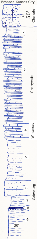
1
|
Massive reddish sandstone, with angular pebbles of dense blue limestone up to 2 inches at the base
|
+ 50 ft.
|
|
2
|
Greenish gray clay shale
|
4 ft.
|
|
3
|
Silty buff shale and interbedded bluish gray dense flaggy limestone, no fossils
|
37 ft.
|
|
4
|
Crinoidal, buff shaly limestone, poorly shown
|
+/- 6 ft.
|
|
5
|
Covered sandstone and shale
|
18 ft.
|
|
6
|
Massive buff sandstone unconformable on shale below
|
7 ft.
|
|
7
|
Silty gray shale 4 to 6 feet
|
5 ft.
|
|
8
|
Coal 0.5 feet with thin underclay
|
0.7 ft.
|
|
9
|
Gray silty shale, not well shown
|
+ 30 ft.
|