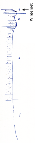
KGS Home

Geology Index Page

Montgomery County

Sec. 16, T. 33 S., R. 17 E
Move to another county

Measured By Refer to Notebook No. 26B, 6/16/1933
Unit No. Description Thickness
4 Limestone, flaggy at top, sandy near base, Marginiferas, crinoid stems. Winterset limestone 1 - 2 ft.
3 Sandstone, massive 6 - 8 ft.
2 Sandstone and sandy shale, nearly all well exposed, no coal seen 37.8 ft.
1 Mostly covered. Shale and sandstone. Sandstone at base 20 ft.

Original Document

The Archive file you download contains a TIFF image compressed into a ZIP archive. Your browser may be already set up to decompress these files. Commercial software to perform this is available from PKWARE, Inc., the company that invented the format. A web page from a group of people creating shareware or public domain software is available at Info-ZIP. The TIFFs are 150-dpi archival-quality color scans of the original forms and can be viewed by software like Corel PhotoPaint or Adobe PhotoShop.


Kansas Geological Survey
Comments to webadmin@kgs.ku.edu
URL=http://www.kgs.ku.edu/General/Geology/Measured/index.html
Programs Updated May 2003