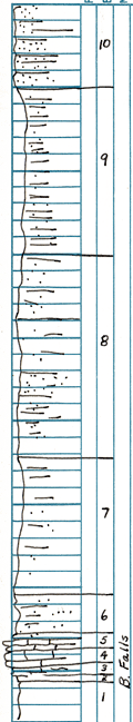
KGS Home

Geology Index Page

Montgomery County

Sec. 15, T. 33 S., R. 17 E
Move to another county

Measured By J.M. Jewett, 6/19/1941
Unit No. Description Thickness
10 Sandstone, massive, clean cut contact at base 10 ft.
9 Shale - non-sandy in upper part, light gray 28 ft.
8 Sandy - shale & sandstone, some massive sandstone 16.2 ft.
7 Sandy, shale & sandstone, clay 11.2 ft.
6 Sandy, shale 5.4 ft.
5 Limestone - shaley & shale chonetes, crinoid stems 1.5 ft.
4 Limestone, in two beds, dark and light gray, many crinoid stems 1.66 ft.
3 Limestone and limy shale, nodular, crinoidal 0.66 ft.
2 Shale - small crinoid stems, coal at base 0.5 ft.
1 Shale, limonitic plant fossils 3 ft.

Original Document

The Archive file you download contains a TIFF image compressed into a ZIP archive. Your browser may be already set up to decompress these files. Commercial software to perform this is available from PKWARE, Inc., the company that invented the format. A web page from a group of people creating shareware or public domain software is available at Info-ZIP. The TIFFs are 150-dpi archival-quality color scans of the original forms and can be viewed by software like Corel PhotoPaint or Adobe PhotoShop.


Kansas Geological Survey
Comments to webadmin@kgs.ku.edu
URL=http://www.kgs.ku.edu/General/Geology/Measured/index.html
Programs Updated May 2003