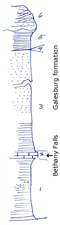
KGS Home

Geology Index Page

Montgomery County

Sec. 15, T. 33 S., R. 17 E
Move to another county

Measured By J.M. Jewett, 6/13/1932
Refer to Notebook Section No. 15 B.
Unit No. Description Thickness
6 Sandstone, irregular beds, shap contact with shale below, slightly cross bedded, beds thin to massive, irregular base 6 ft.
5 Shale 4 - 5.5 ft.
4 Coal 0.7 ft.
3 Mostly, thin bedded micaceous sandstone, lower 10 ft. mostly shale 66 ft.
2 Limestone, in two beds, many crinoid joints 1.6 ft.
1 Shale, clay, very fossilifrous at top, crinoid stems and spines, brachiopods. Neospirifer triplicatus, Spiriferina Kentuckiensis. Fossils are in upper 1 foot which is very calcareous, some sandstone in this interval 16 ft.

Original Document

The Archive file you download contains a TIFF image compressed into a ZIP archive. Your browser may be already set up to decompress these files. Commercial software to perform this is available from PKWARE, Inc., the company that invented the format. A web page from a group of people creating shareware or public domain software is available at Info-ZIP. The TIFFs are 150-dpi archival-quality color scans of the original forms and can be viewed by software like Corel PhotoPaint or Adobe PhotoShop.


Kansas Geological Survey
Comments to webadmin@kgs.ku.edu
URL=http://www.kgs.ku.edu/General/Geology/Measured/index.html
Programs Updated May 2003