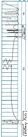
KGS Home

Geology Index Page

Montgomery County

Sec. 20, T. 33 S., R. 17 E
Move to another county

Measured By J.M. Jewett, 6/21/1932
Refer to Notebook No. 27B
Unit No. Description Thickness
9 Sandstone, fine grained, well bedded 8 ft.
8 Shale, yellow and gray 3.2 ft.
7 Coal 1.4 ft.
6 Shale 0.4 ft.
5 Coal 0.2 ft.
4 Shale 2.4 ft.
3 Coal 0.1 ft.
2 Lower part covered, but upper half shows much sandstone and sandy shale, measured over 1/2 mile slope, may be somewhwat less due to West dip 93 ft.
1 Limestone - Bethany Falls - poorly exposed along road side not far from creek ? ft.

Original Document

The Archive file you download contains a TIFF image compressed into a ZIP archive. Your browser may be already set up to decompress these files. Commercial software to perform this is available from PKWARE, Inc., the company that invented the format. A web page from a group of people creating shareware or public domain software is available at Info-ZIP. The TIFFs are 150-dpi archival-quality color scans of the original forms and can be viewed by software like Corel PhotoPaint or Adobe PhotoShop.


Kansas Geological Survey
Comments to webadmin@kgs.ku.edu
URL=http://www.kgs.ku.edu/General/Geology/Measured/index.html
Programs Updated May 2003