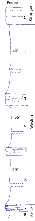
High outlier N. of Caney
Measured By Newell, 8/1935
|

|
|
|
| Unit No. |
Description |
Thickness |
|
1
|
Massive irregular sandstone
|
+ 8 ft.
|
|
2
|
Covered clay shale
|
40 ft.
|
|
3
|
Gnarly irregular sandstone (may not be in place)
|
3 ft.
|
|
4
|
Clay shale covered
|
65 ft.
|
|
5
|
Blocky brown sandstone in even beds 1 - 4 feet
|
4 ft.
|
|
6
|
Bluish clay shale with limonite concretions
|
50 ft.
|
|
7
|
Cross bedded bluish sandy oolitic limestone, conglomeratic below, thin-bedded siltstone at base
|
3 ft.
|
|
8
|
Gray clay shale
|
|
|
|
Total
|
162 ft.
|
|
Original Document
The Archive file you download contains a TIFF image compressed into a ZIP archive.
Your browser may be already set up to decompress these files.
Commercial software to perform this is available from
PKWARE, Inc., the company that invented the format.
A web page from a group of people creating shareware or public
domain software is available at Info-ZIP.
The TIFFs are 150-dpi archival-quality color scans of the original forms and can be viewed by software like Corel PhotoPaint or Adobe PhotoShop.
|
