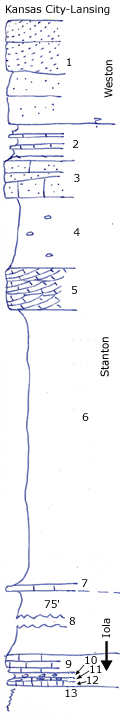
| Unit No. |
Description |
Thickness |
|
1
|
Massive, cross bedded sandstone
|
+ 15 ft.
|
|
2
|
Whitish papery sandy shale and thin sandy oolite beds with Myalina and Worthenia
|
5.5 ft.
|
|
3
|
Massive sandy limestone with molluscs, interbedded with coarse sandstone
|
5 ft.
|
|
4
|
Dark gray clay filled with large phosphatic concretions
|
10 ft.
|
|
5
|
Dark-gray, cross bedded coarse limestone oolite, contains Squamularia and Enteletes
|
3 - 10 ft.
|
|
6
|
Gray clay shale with limonite
|
40 ft.
|
|
7
|
Yellowish flaggy silty limestone poorly shown
|
0.5 ft.
|
|
8
|
Gray clay shale covered
|
75 ft.
|
|
9
|
Yellowish crinoidal limestone (contains Rhynchopora, Girtycoelia beiyamini)
|
2.5 ft.
|
|
10
|
Marly shale with phosphatic concretions below
|
0.8 ft.
|
|
11
|
Irregular, bluish, earthy limestone with obscure "worm-borings" and cryptozoans, crinoid stems
|
0.7 ft.
|
|
12
|
Granular, crinoidal limestone
|
0.3 ft.
|
|
13
|
Platy sandstone (Chanute)
|
+ 10 ft.
|