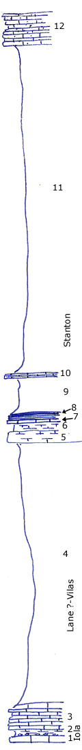
| Unit No. |
Description |
Thickness |
|
12
|
Sandy, oolitic crinoidal limestone, thin bedded caps escarpment
|
+ 5 ft.
|
|
11
|
Covered clay shale with limonite concretions
|
49 ft.
|
|
10
|
Non-fossiliferous drab, silty, platy limestone, weathers buff
|
0.8 ft.
|
|
9
|
Very fossiliferous limy gray shale with molluscan Liongynchus fauna of Warin and Copan; Liorhynchus, Nuculopsis, Conocardim, Trepospira sphaerulata, Worthenia tabulate, Phaneratrema grayvillence, etc.
|
5.5 - 6 ft.
|
|
8
|
Block carbonaceous shale
|
1 ft.
|
|
7
|
Shaly crinoidal limestone
|
0.3 ft.
|
|
6
|
Gray and buff limy shale
|
1 ft.
|
|
5
|
Marly buff crinoidal irregular limestone with algal coated molluscs
|
2 ft.
|
|
4
|
Lower half gray clay, upper half silty gray; well exposed in ditch
|
40 ft.
|
|
3
|
Thin bedded crinoidal limestone with shaly breaks, no fossils but crinoid stems
|
2.5 - 3 ft.
|
|
2
|
Gray, very limy shale, spherical phosphatic concretions at the base where shale is darker gray
|
1 ft.
|
|
1
|
Light gray cryptozoan limestone not over
|
+/- 1 ft.
|
|
|
Number 12 is certainly not the top of the Stanton but may be scores of feet below the top.
|
|