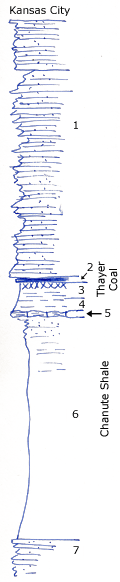
Road exposures
Measured By Newell, 8/1935
|

|
|
|
| Unit No. |
Description |
Thickness |
|
1
|
Platy sandstone
|
35 ft.
|
|
2
|
Coal
|
0.8 ft.
|
|
3
|
Underclay
|
1 ft.
|
|
4
|
Clay shale with plant fossils
|
3 ft.
|
|
5
|
Yellow, nodular limestone
|
0.6 ft.
|
|
6
|
Shale, upper part silty and sandy, most of the remainder gray clay with limonite concretions
|
+/- 35 ft.
|
|
7
|
Platy sandstone
|
|
|
Original Document
The Archive file you download contains a TIFF image compressed into a ZIP archive.
Your browser may be already set up to decompress these files.
Commercial software to perform this is available from
PKWARE, Inc., the company that invented the format.
A web page from a group of people creating shareware or public
domain software is available at Info-ZIP.
The TIFFs are 150-dpi archival-quality color scans of the original forms and can be viewed by software like Corel PhotoPaint or Adobe PhotoShop.
|
