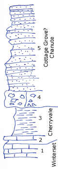
KGS Home

Geology Index Page

Montgomery County

Sec. 6, T. 35 S., R. 16 E
Move to another county

Highway just West of Coffeyville
Measured By Newell, 10/1934
 
Unit No. Description Thickness
5 Platy, Croun, micaceous sandstone +/- 25 ft.
4 Limestone conglomerate, gray and brown; with subangular cobbler of limestone up to 9" in diameter. Pebbles of oolite, dense blue flagstone, brown limestone, phosphatic concretions, a few large worn productids and anoid stems 3 - 4 ft.
3 Papery buff silty shale some gray 7 ft.
2 Fine grainy, argillaceous limestone blocky, none fossiliferous, with thin shale below 14 ft.
1 Crinoidal, granular, fossiliferous limestone with Marginifera, Echinocondius, Fistulifora, etc.  

Original Document

The Archive file you download contains a TIFF image compressed into a ZIP archive. Your browser may be already set up to decompress these files. Commercial software to perform this is available from PKWARE, Inc., the company that invented the format. A web page from a group of people creating shareware or public domain software is available at Info-ZIP. The TIFFs are 150-dpi archival-quality color scans of the original forms and can be viewed by software like Corel PhotoPaint or Adobe PhotoShop.


Kansas Geological Survey
Comments to webadmin@kgs.ku.edu
URL=http://www.kgs.ku.edu/General/Geology/Measured/index.html
Programs Updated May 2003