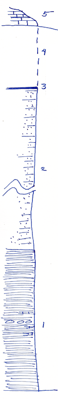
Measured By J.M. Jewett, 10/2/1932
|

|
|
|
| Unit No. |
Description |
Thickness |
|
5
|
Winterset limestone (base 158 feet above River)
|
|
|
4
|
Covered
|
13 ft.
|
|
3
|
Coal (145 feet above River)
|
|
|
2
|
Sandy shale and sandstone
|
|
|
1
|
Shale, blocky, very slightly carbonaceous with dense blue limestone in small concretions and thin beds
|
30 ft.
|
|
|
Base of Section is about 45 feet above River
|
|
|
Original Document
The Archive file you download contains a TIFF image compressed into a ZIP archive.
Your browser may be already set up to decompress these files.
Commercial software to perform this is available from
PKWARE, Inc., the company that invented the format.
A web page from a group of people creating shareware or public
domain software is available at Info-ZIP.
The TIFFs are 150-dpi archival-quality color scans of the original forms and can be viewed by software like Corel PhotoPaint or Adobe PhotoShop.
|
